
Cape Alava is at the far western edge of the continent, facing the wild Pacific. It is truly one of the ends of the earth. The drive alone takes one from small town to smaller town, and then out into the countryside before one reaches Lake Ozette and the trailhead for Cape Alava. The hike itself is through rain forest and field, much of it along boardwalks, and it ends with a descent to the sea. Here the beaches are wild and wonderful and palpably remote.
There are two routes you can take from Port Angeles. You can take route 101 west to the junction with route 112 a few miles west of town. Route 112 will take you to the twin towns of Clallam Bay and Sekiu. Alternatively, you can take 101 west past this junction to Sappho, where you can take 113 north to where it meets with 112 shortly before Clallam Bay. The former route is wilder, but offers some neat coastal views. The latter route is an easier drive, but takes about the same driving time.
From Clallam Bay and Seiku, continue west past Sekiu and go down the
hill. Near the bottom of the hill you will see signs for the
Hoko-Ozette
Road. Take the left turn here and go for 21 miles. The road ends at the
trailhead.
NOTE ON TIDES: It is a good
idea to check out the tide tables
before driving out for this hike. It can be done at high tide, but it
is much more fun at low tide. We also have an iCal calendar you can use
to find good days to hike
the Cape Alava loop.
UPDATE 06/24/04: The Hoko-Ozette road is still in
excellent condition. There is just a bit of left over gravel. At least
one edifice en route has degraded from delapidated to decrepit. The
Sandy Point trail is being rebuilt, and there are some parts of it that
are just support logs and piles of gravel, but it is still easy going.
The new gravel and clay segments of the trails are a delight, as they
do not get slippery when wet, and they feel good under foot.
 This trail starts at near the ranger station and takes you
to the edge
of the world. The station itself is spartan, with minimal running water
and signs advising you to carry your own trash back to civilization.
The
only facility here is The Last Resort, a general store.
This trail starts at near the ranger station and takes you
to the edge
of the world. The station itself is spartan, with minimal running water
and signs advising you to carry your own trash back to civilization.
The
only facility here is The Last Resort, a general store.
Then you go over the bridge. You can look down at the fish channel which forces the fish here to pass by the video camera and be counted in the fish census. Then things start to get wilder.
A bit after the bridge, you will get to the fork, where the Cape Alava trail and the Sandy Point trail meet. If you want a shorter hike to the sea, Sandy Point is 3 miles away, against Cape Alava's 3.3 miles. We usually take the Cape Alava route to the sea. The trail is more strenuous, but also prettier than the latter. We save the easy route for our exhausted return.
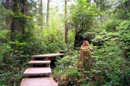
Very soon after the fork you are on the boardwalk. This can get slippery on wet days, but it is much, much better than the mud one had to trek through up until the 1970s. The trail goes down into secret valleys with ferns and skunk cabbage, and then up, past giant trees and murky forest. On through the green world it runs, up and down the wooden steps, across the endless wooden planks.
Do watch your step. Some of the planks rock, some are missing, and there are sometimes hard to see steps down that can trip you up.
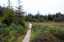 About 45 minutes into the hike, you emerge in Alstrom's
Meadow, which
was once part of a farm, but has now reverted to swampy meadow. In the
spring,
the fields are full of azalea, but you can find flowers in any season.
About 45 minutes into the hike, you emerge in Alstrom's
Meadow, which
was once part of a farm, but has now reverted to swampy meadow. In the
spring,
the fields are full of azalea, but you can find flowers in any season.
After the meadow comes the darkened forest with its great trees, then, at long last the air freshens and the trail starts its descent to the sea. Pretend you are Balboa boldly approaching the Pacific, exploring the undiscovered, braving the wilderness, looking for stuff to steal and natives to enslave, Maybe not.
As you approach the sea, the boardwalk ends and you must traverse the nettle and thistle infested hillside as you approach the beach below.
If you want, you can just explore the beach here, heading north or south, and then head back along the Cape Alava Trail. But, if you are hearty and want an extraordinary hike, head south to Sandy Point where you can complete the loop.
 Cape Alava to Sandy Point
It is a good idea to take this trail at low tide. If nothing else, this gives you more walking space on the beach and lets you avoid having to take the inland routes at various headlands.
At any time, this is a rugged hike. Walking in sand can be tiring and clambering along rocks treacherous. On sunny days, avoid the green seaweed on the rocks, as it is extremely slippery, but once the rain begins, the seaweed is a welcome respite, as the rocks themselves become even more slippery.
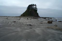
There is no formal trail. Just follow the beach. Head out and explore the tidepools and clamber on the rocks. Enjoy the mysterious sea stacks along the way. These are miniature islands, eroded and exotic, like little worlds unto themselves.
After the first headland going south, there are the petroglyph rocks. These can be hard to find, and at one point, there were nearly twenty of us, miscellaneous visitors and one ranger, clambering around looking for them. There is at least one petroglyph of a whale and there is supposed to be a fertile couple on the so called Wedding Rocks. We never found this.
 Continue south to the next beach and then through the sea
stacks. In
season, wild strawberries grow here, but you have to be willing to
climb.
Also, watch for deer. They are fearless here, so you can get great
photos
without a telephoto lens. Do be careful and don't trip over the fawns
when
the mother is watching. She might get upset.
Continue south to the next beach and then through the sea
stacks. In
season, wild strawberries grow here, but you have to be willing to
climb.
Also, watch for deer. They are fearless here, so you can get great
photos
without a telephoto lens. Do be careful and don't trip over the fawns
when
the mother is watching. She might get upset.
The going gets a bit easier on the broad sands of the next beach, and then you round another headland - or is it two - we lose count - and you are approaching Sandy Point.
Depending on the weather the hike can seem a different world. On cloudy days, the beach and sky are gray, but one can see the headlands far away in the haze. The air is fresh and clear. On sunny days, the icy Pacific creates its own fog and it is often impossible to see past the next headland. Sea stacks loom distantly in the mist. The air is hot and heavy.
In either case, at low tide, the waves break far out at sea, almost as if there are two oceans. The distant one of mighty waves and the closer one of the tidal flats.
The final beach is lined with driftwood, and the trailhead back to the ranger station is farther down than you might think. It is easy to be lured into one of the forest passageways, just to explore, but these trails do not go far. Head onward and watch for the circular sign. If you still have strength, head on further south.
However, if you are like us, you will be more than glad to leave the sun and wind and glare of the sea, and return to the forest trail home.
This trail is much like the Cape Alava trail, but it is less strenuous and less interesting. Usually, by the time we reach it, this does not matter. We are glad to be heading home.
This is not to say it is without its merits. Most of the trail is boardwalk and passes through the coastal forest, but there are no wilderness meadows and much of the forest is recent growth. Check the larger tree trunks for signs of fire. The trail climbs slowly, and with fewer peaks and valleys than the Cape Alava Trail. The forest only thickens near the junction, but then the journey is nearly over. Except, of course, for the drive home.


© Copyright Kaleberg Symbionts 2004