|
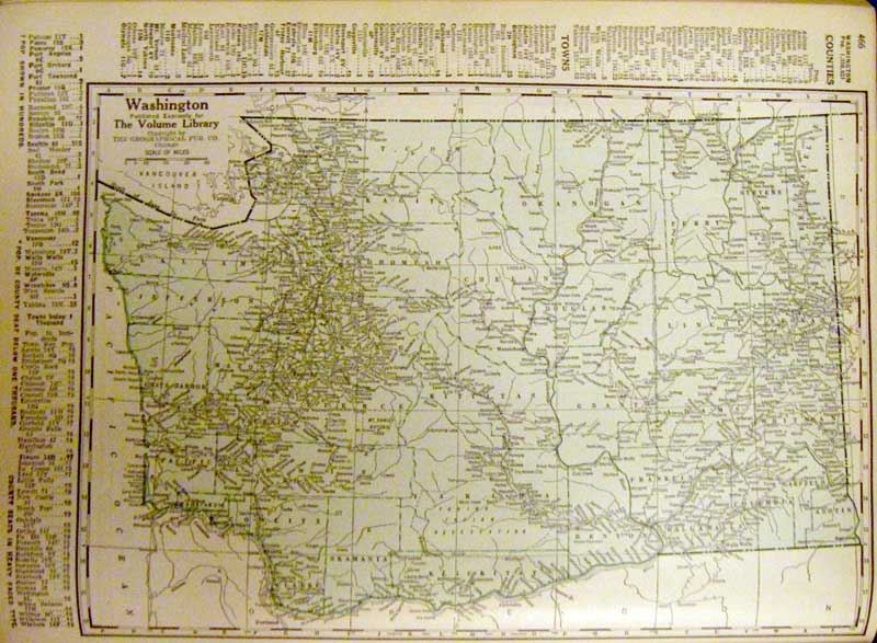
We were looking at an old map of Washington State in an early 1930s edition of The Volume Library and couldn't help noticing that there seemed to be a lot more towns west of Port Angeles back then. For example, there was the town of Ramapo, right there on the statewide map. What was Ramapo? Where is it today? There were even towns west of Joyce; the next town was Hilda, and even further west, there was the town of Majestic. How could we not have heard of a town named Majestic? We had driven out west on route 112, but we had never noticed any signs for Majestic. |
The map that started it all |
|
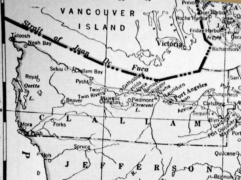
There were an awful lot of towns west of Port Angeles. |
The map dates back to before the completion of route 101 out to Forks. There's a road out to Tatoosh, but not much else. Presumably, there were a few other roads, but a lot of traffic followed the rivers. For what it lacks in roads, the map compensates with a surfeit of towns. Port Angeles, Sequim and Forks are there, but there are also towns like Ivan, Ramapo, Twin, Lauridsen, and Hilda. Of course, Port Angeles back then wasn't the thriving metropolis it is today, but it is still here. Where are all of these other little towns? |
|
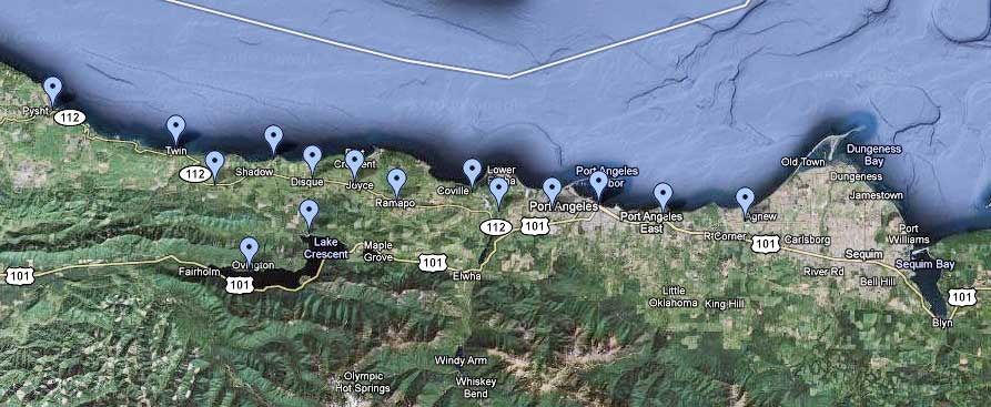
Google Maps view of the region. (Click for the actual live map). To figure out where these towns are now, we went to the source, Google Maps, every man's geographical information system (GIS). Some of the towns on the old map are still on maps today, though you won't notice any signs if you drive by. Other towns seem to survive in road names. A few towns seem to have vanished completely, either swallowed by the wilderness or by Port Angeles and modernity. |
|
|
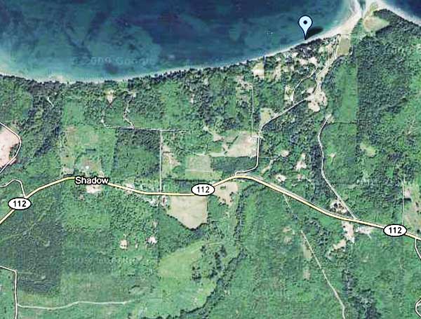
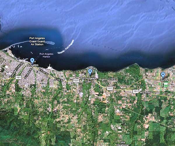
Hilda First, we wanted to find Hilda. There is actually still a Hilda, WA, but it's located down south near Centralia. That's not our Hilda. If you head west from Joyce on 112, you do run into a town called Disque. It's a bit before Whiskey Creek Road. We're going to guess that Hilda has either been renamed Disque, perhaps by a Frisbee fanatic, or refers to the area around where Whiskey Creek crosses route 112. |
The search for Hilda |
|
Gettysburg The next town west was Gettysburg which is shown as being along the Strait. There are two possibilities here. There is some development at the mouth of the Lyre River. That might have been Gettysburg. There is also a town designated Shadow, a fair bit west along route 112, so a bit inland. We're going to guess that Gettysburg was at the mouth of the Lyre. For more - see the update below. |
Clearly not Lincoln's Gettysburg |
|
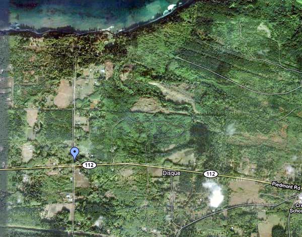
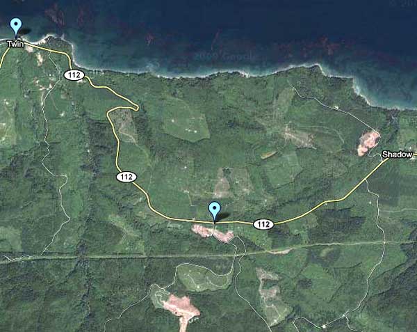
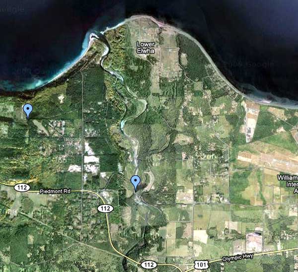
Majestic Majestic is shown as being inland, west of Gettysburg, but east of Twin. Twin is still on modern maps, but Majestic has dropped out somehow. Following route 112 doesn't show much. There aren't a lot of houses or side roads out that way. We've put our marker next to a clear cut. Obviously, that clear cut wasn't around 75 or 80 years ago, but there isn't much else to go on. At least it shows up on the satellite imagery. |
Majestic? |
|
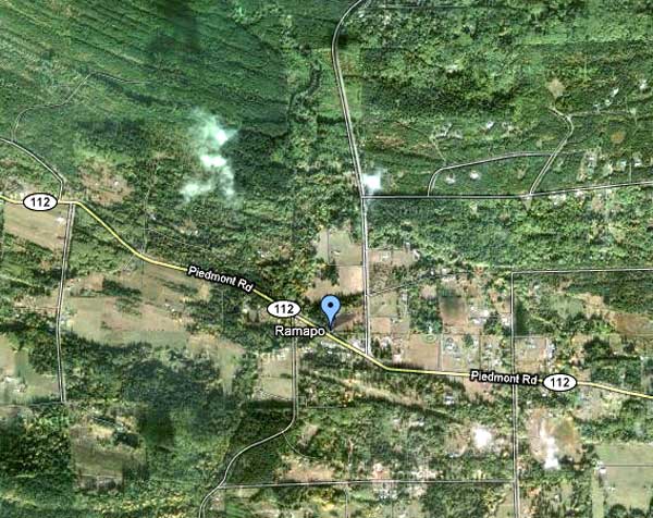
Ramapo There is a Ramapo Road not far, but we placed Ramapo, the next town east of Joyce, at the junction of route 112 and Camp Hayden Road. There used to be a general store there, complete with a state hard liquor license, but now it's a private residence. There's also the golf course and the guy selling firewood. |
There is a Ramapo Road, but ... |
|
Ranger Our clue here was Ranger Road which goes west from Place Road. We're marking the area near Ranger Road, but most likely the town of Ranger has been renamed Coville. We aren't too sure about Coville to be honest, but we did find it on the internet. |
|
|
Elwha We would have guessed the Lower Elwha reservation for this one, but the map shows the town on the west side of the river. We're going to leave it there and guess that Elwha was somewhere near the lower Elwha dam. For all we know it was flooded when the river was damned. Route 102 takes a suspicious turn there. |
|
|
Lauridsen Lauridsen has been swallowed by Port Angeles. We'll put Lauridsen out near the airport at the west end of Lauridsen Boulevard. Since the city has grown up around the town, there aren't a lot of clues visible from the air. Next time we fly Kenmore Air, we'll see if we can recognize a town within a town. Some folks found an old farming own in Brooklyn that way, by looking for patterns of old farmhouses among more recent buildings from the air. |
|
|
Ivan There are two of possibilities for Ivan. It is a bit closer to Port Angeles than to Agnew, so our favorite guess is that Ivan is now known as East Port Angeles, home and future home of Walmart and Blue Flame Barbeque. There is a town called Crane to the east of Morse Creek, and it is possible that Ivan was renamed Crane. Of course, Crane is much closer to Agnew than to Port Angeles. We'll guess that Ivan is East Port Angeles, at least until we get some new evidence. |
|
| READER UPDATE from JB - 7 March 2015 If you haven't already found out, a number of those "towns" were actually railroad stops or infrastructure that developed around a logging camp. Disque, Shadow, and Hilda were all RR stations. Gettysburg was a small town developed around a logging camp, not much beyond a hotel, post office, and other buildings necessary for the logging industry. It was developed by Robert Getty in the late 1880's, about 1/2 mile east of the mouth of the Lyre River. |
But many people referred to the whole surrounding area as
Gettysburg (suburbs, maybe?). You can find pics at Washington
state archives or a number of books. Later, about 1911, things did
develop a lot more on the east side of the mouth of the Lyre
around a shake mill operated by the Mackie family. Post office
moved there and there were quite a few outbuildings (I have a
picture). My grandfather owned about 130 acres, mostly on the west
side of the Lyre River and my family still owns quite a few acres
on both sides of the river. Hope this helps. |