Tide Tables for Dungeness, Washington
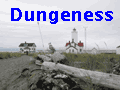
Dungeness Spit juts nearly five
miles out into the Strait of San Juan de Fuca. You can walk along the beach
to the lighthouse, way out at sea. Do check the tides, and check out our
notes on the hike and some pictures. We also have an iCal
calendar showing some good days for hiking the spit.
NOTE: These tide tables were
generated using XTide 2.6, an
open source tide table generator. Our experience indicates that they are
fairly accurate, but we've seen minor variations between these tables and
other published and online tables. We make no claim as to their
accuracy.Hiking Pacific beaches can be dangerous. Even at low tide you can
encounter a rogue wave. Remember that you are hiking at your own risk. These
tables are good for planning a trip, but as always, keep your eyes on the
ocean and the beach logs.