Salt Creek Park is one of those local gems that tends to pass under the radar of most tourists. It really can't compete with the Olympic National Park to its south, but it does have charms of its own. One of these is Striped Peak which offers a good climb and wonderful views. There is also a playground, great views from the rocky coast and you can walk right down to the sea and explore the rocks or go scuba diving.
Head west from Port Angeles on route 101 to the junction with route 112 to Joyce. Head towards Joyce and keep your eyes open for Salt Creek Park on your right. The actual road is Camp Hayden Road and there is a little general store just past the junction. Follow Camp Hayden Road north until you see the park entrance. The road turns left here, but the entrance is straight ahead. Park near the playground/playing field and get out and explore.
 Striped Peak
If you park at the playground/playing field, head back south along the road towards the park entrance and go left just before the free firewood supply and entrance station. There is a barrier across the road and you go around it to the right to get on the trail.
The first part of the trail is wide and can be a bit muddy. It climbs steeply past ferns and forest until you reach the bunkers. These are World War II left overs and you can head straight to explore them, or go right and continue your ascent.
Here the vegetation gets scrubbier and you'll find a lot of scotch broom, an invasive outsider, and the climb continues steeply. We consider Striped Peak a great training hike in the winter season. It may get muddy, but it rarely snows at these altitudes, but you still have to work hard to climb.
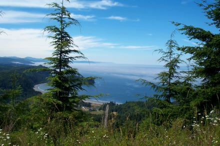
The trail continues its ascent without many views until you are nearly 2/3 the way up. Then you get the first inland view. Another steep corridor up and you get to the junction with the access road. It seems to be open to cars, but we've never seen anyone driving up here. Some people must like their axles. Continue up just a bit farther and the views of the strait start. Down below you can see Salt Creek, we presume, and Carol's Crescent, a private beach park.
There are particularly good views from an overlook that seems to be the local teen recreation center. Check for beer bottles, contraceptive foam applicators and shotgun shell casings and you'll see why Striped Peak isn't on the International Great Places list. Better yet, just look out north and check out the Canadian coast and vibrant blue water. That's Mount Baker a bit to your right.
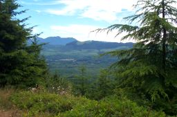
If you head just a bit higher, to the top of the trail, you can get a view east towards Port Angeles and can see the Dungeness flatlands ahead.
Just reverse your steps to get down to the trailhead.
Starting at the playground/playing field parking lot you can either head south along the road and go left just before the entrance station, or you can cut across the playing field and look for the trailhead at the back corner. The advantage of the former approach is you get a sign explaining that this is a trail to a cove and a vista point further on and that the trail is not suitable for horses. The latter approach is shorter.
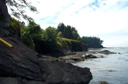
Follow the trail up and then down to the coast. You'll be in the woods, but as you head onward you'll get views of the rocks below along the coast. We've seen seals and sea birds down below us, so you might want to bring binoculars. This can be an arduous trail with lots of ups and downs, but the footing is good for the most part.
There is a well marked side trail which gets you down into the cove you've been seeing from the main trail. We've gone down a ways, but haven't made it to sea level yet. Alternatively, you can continue onwards towards the advertised "vista point", but we haven't gotten this far either. Despite our failings, this is a really nice trail and can be especially nice on a rainy day with its forest shelter and ocean views.
 The Rocks
This isn't really a trail. You head down to the sea from the playground/playing field parking lot and there is a stairway down to the rocks. There is a sign here with some underwater photos and an explanation that this is a good spot for cold water scuba divers. It is supposed to be one of the best entry sites in the area, so if you do scuba, you might want to check it out.
We don't scuba, so we do what most people do down here. We walk out on the rocks. At low tide you can go quite a ways. If you explore the campground, you'll find at least one other staircase down to the rocks, so there is a lot to explore here.